Tuesday 25 September 2012


What is the geometrical interpretation of Machu Picchu?

Machu Picchu steep slope

Theories about the alignment of rocks have been made by various scientists, researchers and historians since the last decade. But they didn’t find any solid proof of their alignment, how they can resist the seismic waves for so many years. According to researches, the cutting of the rocks and stones, with different shapes and sizes placed properly, the use of locally available rocks from the Urubamba river, the  use of locally made tools used during constructions, etc. are a few important points to look for the answer of the given question.
I have gone through a few texts and videos about the wonder of the World. Experts are of the opinion that there is no geometrical formula of the town planning of the citadel. I totally agree with them. But the citadel has some underlying geometrical interpretation, i.e. the alignment of rocks on the slopes of the mountain with the fault plane beneath them. 

The stairs
 The polygonal shape of the rocks helps to fit in properly. The edges are usually carved sharp for proper fitting. In times of earthquakes, the rocks tremble as there very less cementing material in between. But they settle down well in their respective places and lock themselves in the predefined orientations. There are structures which are big in size and have a tendency to fall down soon. The structures are too very stable. 

The geometry of alignment of rocks are precise
 
The reason is because the rocks used are well locked and balanced. They are placed in such a way that even if seismic waves attack them, the direction of the attack will always be in a particular way. The Centre of mass and the Centre of gravity are well balanced and beneath the geometrical center so that there is stable equilibrium. Again the foundation is of the citadel is made of different sizes and shapes of rocks, mixed with the soil to have the stability. Thus, the citadel as a whole is really a wonder of earthquake engineering. 

The steep slope
 I think the design of the citadel should be practiced in our present day structures. Although it will be a tedious work, but, it sure will resist the high magnitude seismic waves.

Friday 21 September 2012

THe Robot's blood


The Gen-next technology

The technology that joined hands with many fields of engineering such as civil, mechanical, electrical and electronics is popular known as the M R Technology. The M R Technology is completely based on the fluid prepared, to be used to minimize the dynamic forces of nature. Starting from the brakes in automobiles, to buildings subjected to wind and earthquake loads, all the structures however big or small it may be, use this latest technology. It is said that the fluid is used as blood in the next generation robots. That is why it is also called ‘Robot’s Blood’. But my concern is all about its use in the civil engineering structures, subjected to seismic loads. 


Disasters such as earthquakes, cyclones, floods and other similar phenomena cause large-scale damage to lives and environment. The most remarkable challenge in civil engineering is to protect the structures from these hazards and a lot of research is being carried out world-wide in this field. The device to control the worst effects of earthquakes is known as MR Damper. The MR Damper can be of many types, but we are using the semi-active type of MR Damper. The reason is because it can operate under very low power requirement. Magneto rheological (MR) damper is one of the new technologies designed using MR fluids to produce controllable dampers to serve this purpose. Specially, MR fluid technologies are reliable, inexpensive, and relatively insensitive to temperature fluctuations. This type of damper has high dynamic range, low power requirements, large force capacity and robustness. In order to design the MR damper, a better understanding of MR fluid behavior is very important. The most important property of the MR Fluid is it viscosity. The determination of this property is the toughest part. After that, the fluid of a given viscosity is used in a damper for further testings.

Tuesday 4 September 2012

how plate techtonics are affected by changing magnetic fields of the Earth


The plate tectonic theory says that the plates (oceanic and continental both) are moved due to the convectional currents in the interior of the earth. The interior of the earth includes the mantle and the core. The mantle of the earth is fluid in nature, but the core is hard. The core of the earth is made of NIFE (Nickel and Ferrous (Iron)). The mantle is made of nickel and magnesium. So both the mantle and core are made of magnetic materials.
The alignment of the magnetic materials decides the earth’s magnetic field. The reason for this is the magnetic materials are charged up in the process and they align themselves to form magnetic poles. Now, due to changing magnetic poles, the alignment of magnetic materials are also changing, thus changing the convectional currents inside the earth surface. So this change in convectional currents will change the orientation of the crustal plates of the earth surface. The change in orientation of the crustal plates will induce stress and strain. When the stress and strain will be released in the form of energy, vibrations will occur. The vibrations will cause the shaking of the earth surface (crust). This vibration of the earth is nothing but earthquake.
So we decipher that the changing magnetic poles may be one of the causes for the upcoming earthquakes occurring recently throughout the globe. One good example is that, the recent earthquake in the northern part of India in 2011. It was an unusual occurrence as the region was not so much prone to earthquakes. But the changing magnetic poles might trigger the occurrence of the earthquake.
Thus, we have a firm belief that the changing earth’s magnetic poles are one of the causes of the earthquake.

MACH PICCHU- one of the ancient wonders of the world


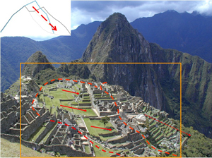
Machu Picchu- became one of the new Seven Wonders of the World in the year 2007, was first discovered by Prof. Hiram Bingham in July 1911. It is situated in the northwest of Cusco, Peru. By the year 1983, it was declared as a World Heritage of Humanity in terms of both cultural and natural beauty by UNESCO. The citadel of Machu Picchu was built by the Incas in the 15th century A.D. But it collapsed by 1540 as the Spanish attacked the city and left it abandoned as centuries.
The citadel of Machu Picchu was built in a zone that is affected by frequent earthquakes and landslides. The citadel is surrounded by Mt. Machu Picchu, Mt. Huayana Picchu, Urubamba River Mt. Putukusi and Mt. Intipunku. The region is again surrounded by Machu Picchu fault on south-eastern side and by Huayana Picchu fault on north-western side. Besides all these features, the citadel is situated high up on the mountain with steep slopes on almost all sides. To view the map of Machu Picchu, click on the link-https://maps.google.co.in/maps?oe=utf-8&client=firefox-a&ie=UTF-8&q=machu+picchu&fb=1&gl=in&hq=machu+picchu&hnear=machu+picchu&cid=0,0,16693313952838919511&ei=H9RFUKjSMs7prQf6soGwDA&ved=0CLIBEPwSMAY
Of all the interesting things found out in this citadel, two features have caught the eyes of most of the scientists and researchers exploring the region. First one is the alignment of the rock masonry structures of the citadel; and second one is how such a citadel is standing firm on a landslide prone area affected by frequent earthquakes of higher magnitudes.
Alignment of rocks:
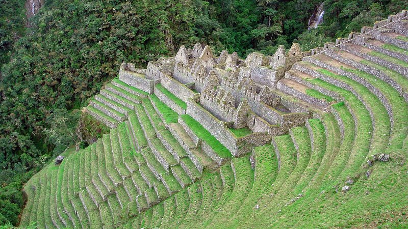
The alignments of rock masonry seem to be done in a random way, but researchers have told that they do maintain a geometric equation. The equations have not been found till now, but it will soon be coming into picture. The buildings were built of granite rocks which are still locally available on the banks of the river Urubamba. They were carved first in different proportions on the banks and then carried to the site. The walls of the buildings were made of uneven shaped and sized rocks. They look uneven, but are actually complement in shape to the next rock block. With the majority of Machu Picchu created using this technique it displays the excellent craftsmanship of the Inca people and how they had mastered the building technique called Ashlar. This complementary property of Ashlar helps the heavy rock blocks to stay intact even in high frequency earthquakes and landslides without the use of cement paste used in between the rocks. The stones of the dry-stone walls built by the Incas can move slightly and resettle without the walls collapsing. The walls are usually rounded with the inside corners inclined slightly into the rooms. The corners ate tied using L- shaped blocks from outside. Many junctions in the central part of citadel are so perfect that it is said not even a blade of grass fits between the stones.
Description: M:\Inca architecture - Wikipedia, the free encyclopedia_files\220px-CuscoPiedra12angulo.jpgDescription: Wall at Machu Picchu.
Figure 2. Walls at Machu Picchu

Most of the buildings in Machu Picchu are one-storey high and rectangular shaped with trapezoidal doors and windows, but with uneven carved surfaces. This is due to the fact that they used harder rocks to carve softer ones with simple rocky tools. There is only portion of the citadel where there is differential settlement of the wall. Other than that portion, most of the citadel is perfectly intact. The different size of the rocks placed one after another, may be helping in stabilizing the buildings. There must be absence of stress points concentrations and resonant frequencies in these buildings. This very hypothesis is unknown to the researchers and scientists. A sample of the differential settlement of stone masonry structure is shown in the figure 2.


Figure 3. Differential settlement of wall
Stabilizing the citadel on a landslide prone area:
The citadel stands several metres above the valley of the River Urubamba. The region is affected by frequent landslides which are caused by earthquakes of higher magnitudes. The epicenter may not be in Machu Picchu but they lie within radius of several hundreds of kilo meters. After the recent Hawaii Earthquake of 2006, there has been a pattern of disaster in the buildings of the citadel. A few of them are –
1.      Block-on-block sliding(in figure 4)
2.      Wall or column bending(in figure 4)
3.      Wall rupture due to differential settlement( as in figure 3)
4.      Wall bulging, bending and settlement due to foundation failure at the bottom of the slope(in figure 5)
Historians and researchers tell that there had been a landslide when Inca civilization was on its peak of glory. One side of the slope was destroyed along with its wall and foundation. They re-built the structure with fine size soil on top layers and big boulders at the bottom. Thus the citadel became again.

Figure 4. Failure due to sliding and bending

Figure 5. Failure due to bending, bulging and settlement
The researchers are telling that the stability of the citadel lies in the use of locally available granite rock as building material and unique combination of uneven size and shaped rock masonry. Besides these features the roof tops of the houses were such made that they are not destroyed by high speed winds flowing on the top of the mountain. In 2005 and 2009, the University of Arkansas made detailed laser scans of the entire Machu Picchu site and of the ruins at the top of the adjacent Huayana Picchu Mountain. The university has made the scan data available online for research purposes. All these extraordinary features of Machu Picchu have made into a wonder of the world and a masterpiece of Civil Engineering during and after the Inca Civilisation.
References:
1.      Brown Jeff L. (2001), “Rediscovering the lost city”, Civil Engineering magazine.
2.      Medley et.al. ((2007), “Seismic Performance of Rock Block Structures with observations from the October 2006 Hawaii Earthquake”, ICEGE Greece.
3.      Cardier Beth (2009), “Seismic Semantic Federation:The view from Machu Picchu”, University of Melbourne, Australia.
4.      Sassa Kyoji, Fukuoka Hiroshi, Shuzui Haruo, Hoshino Minoru (2003), “Landslide risk evaluation in the Machu Picchu World Heritage, Cusco, Peru”, Japan.